
SWAN ISLAND RESTORATION
- Title: Swan Island Restoration
- State: Maryland
- Project type: USACE
- Greater Beneficial Use Area: Chesapeake Bay; Tangier Sound
- Focus Area(s) approximate center coordinates: 38.0050, -76.0447
- Nearest Federal Navigation Project: Big Thorofare and Twitch Cove
- Owner: USACE Baltimore District
- Project Partners: Maryland Department of Natural Resources, U.S. Fish and Wildlife Service, National Oceanic and Atmospheric Administration's Center for Coastal Ocean Science, and US Army Engineer Research and Development Center
- Beneficial Use Categories: Island Habitats
- Dredge type: Hydraulic
- Status: completed in 2019
- Keywords: Swan Island, shoreline erosion, wave break, adaptive management, Spartina patens, Spartina alterniflora
Description:
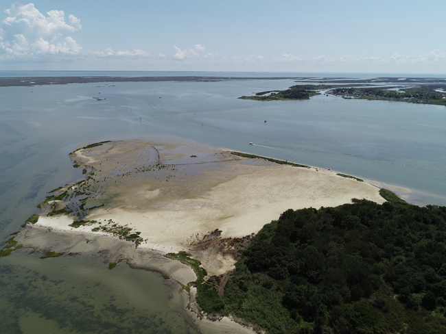
Sea level rise, flooding, and shoreline erosion all pose increasing risks to the nation's coastal communities. Swan Island, part of the Martin National Wildlife Refuge, is located in the Tangier Sound of Chesapeake Bay, Maryland, and acts as a natural wave barrier for the nearby town of Ewell. In Tangier Sound, the strongest winds blow from the northwest, passing over Swan Island, towards Ewell, contributing to the potential for waves to impact the town. High rates of shoreline erosion and subsidence on Swan Island have deteriorated the island's natural habitat, as well as its ability to shelter the town of Ewell from winds and wave action. The town of Ewell is only accessible by boat, therefore, is dependent on the federal navigation channel to provide safe navigation and access. In October 2018, the USACE Baltimore District (NAB) began dredging the Twitch Cove and Big Thorofare navigation channels as part of a 10-year dredge cycle. The traditional confined disposal facility used to dispose of dredge sediment had been filled to capacity, creating an incentive to find alternative placement options and beneficial uses for the dredged sediment. This provided the perfect synergy for island restoration using dredge sediment.
Approximately 60,000 cubic yards of dredged sediment were used to restore the footprint of Swan Island, transforming the island from highly fragmented habitat to ecologically productive high/low intertidal marsh and dunes area, over approximately 12 acres. Containment for dredged sediment consisted of two layers of coir (coconut fiber) logs held in place by wooden stakes. The containment feature was designed to keep sediment from spilling over and impacting the lower elevation submerged aquatic vegetation. Dredge material was placed via pipeline and mechanical grading was use used to ensure target elevations were met.
Planting of native vegetation started in late spring 2019 and was completed July 2019. The island profile included four zones: dunes (Zone A), transition between dune and high marsh (Zone B), high marsh (Zone C), and low marsh (Zone D). Dredge sediment was placed at a higher elevation than initially planned due to the material being sandier than expected and a lack of precision during placement. As a result, the planting regime in Zones C and D was limited to mostly salt-meadow cordgrass (Spartina patens) and smooth cordgrass (Spartina alterniflora), respectively. Switchgrass (Panicum spp.) was planted in Zone B and American beach grass (Ammophila brevigulata) was planted in Zone A. In addition, some areas of shoreline adjacent to dunes were reinforced with armoring to protect against further erosion.
Monitoring and adaptive management at Swan Island allowed for the opportunity to evaluate the efficacy of coastal island restoration measures in enhancing long-term resiliency. Researchers from the US Army Engineer Research and Development Center (ERDC), the National Oceanic and Atmospheric Administration (NOAA) Centers for Coastal Ocean Science (NCCOS), the U.S. Fish and Wildlife Service (USFWS), and Maryland Department of Natural Resources (MDNR) used pre- and post-restoration data relating to sediments, topography, hydrodynamics, and ecology to develop models that quantitatively evaluate the capability of Swan Island to reduce wave energy and erosion of nearby shorelines and habitats. This project required a high-level of collaboration among stakeholders and federal and state agencies to develop project goals and conceptual models. A series of iterative workshops led to the creation of a Monitoring and Adaptive Management Plan. The Monitoring and Adaptive Management Plan serves as a blueprint for tracking changes and exploring the relationship between the island's physical and biological conditions.
After two years of post-restoration monitoring, the high marsh was characterized by vigorous growth of planted S. patens. However, the low marsh experienced significant plant mortality. The monitoring team responded accordingly by planting an additional 25,000 low marsh plants (S. alterniflora). Trends in shoreline erosion, elevation change, and aerial extent of island vegetation continue to be monitored and evaluated with respect to the island's water regime (tides, inundation, wave action, etc.). The results of the Swan Island restoration and monitoring program will be used to inform future island restorations and other coastal resiliency programs. The models simulated as part of the Monitoring and Adaptive Management Plan will help fill information gaps regarding the response of coastal communities to physical forcings like storms and sea level rise. The Swan Island restoration program serves as an example of how scientists are leveraging natural and engineered processes to improve our nation's coastlines.
Websites:
- NCCOS. 2021. Swan Island Restoration: Engineering with Nature (EWN) Principles in Practice. ArcGIS Story Map.
- USACE – Baltimore District Website https://www.nab.usace.army.mil/
Press releases:
- RECONOMICS Institute. 2019. Maryland's Swan Island - on the Verge of Disappearing Due to Erosion - Is Ecologically Restored Via Beneficial Reuse of Dredge. Revitalization Issue #113. December 15.
Further Readings:
- Davis J, Whitfield P, Szimanski D, Golden BR, Whitbeck M, Gailani J, Herman B, Tritinger A, Dillon SC, King J. 2022. A framework for evaluating island restoration performance: A case study from the Chesapeake Bay. Integrated Environmental Assessment and Management. 18(1):42–48.
- USACE. 2021. Swan Island (Chesapeake Bay, Maryland). Built Projects. Engineering with Nature. May 6.
- Whitfield PE, Davis JL, Tritinger AS, Szimanski DM, Golden RR, Gailani JZ, Ramirez MT, Herman BD, Whitbeck M, King JK. 2022. Swan Island Monitoring and Adaptive Management Plan. ERDC TR-22-14. US Army Engineer Research and Development Center, Vicksburg, MS.
- Whitfield PE, Suedel BC, Egan KA, Corbino JM, Davis JL, Carson DC, Tritinger AS, Szimanski DM, Balthis WL, Gailani JZ, King JK. 2022. Engineering With Nature® Principles in Action: Islands. ERDC TR-22-9. US Army Engineer Research and Development Center, Vicksburg, MS.
Videos:
NCCOS. 2019. Swan Island Restoration Begins in Chesapeake Bay.