SEVEN MILE ISLAND & GULL ISLAND
- Title: Seven Mile Island & Gull Island
- State: New Jersey
- Project type: Restoration
- Greater Beneficial Use Area: Cape May, New Jersey
- Focus Area approximate center coordinates: 39.0755, -74.7384 / 39.0798, -74.7779
- Nearest Federal Navigation Project: New Jersey Intercoastal Waterway (NJIWW)
- Owner: USACE Philadelphia District
- Beneficial Use Categories: Wetland Habitats
- Dredge type: N/A
- Status: Ongoing
- Keywords: Restoration, coastal resilience, marsh habitat
Description:
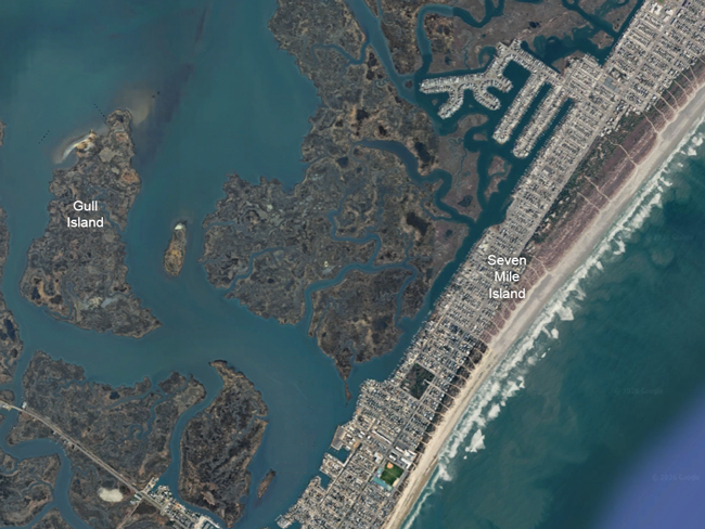
The Seven Mile Island and Gull Island restoration projects are located in Cape May County along the coast of New Jersey, situated within the back-bay system of the New Jersey Intracoastal Waterway (NJIWW) between Stone Harbor and Avalon. This region is highly valuable as it provides critical habitat for fish, shellfish, and migratory and nesting birds, while acting as a vital coastal resilience buffer for local barrier island communities (Chasten et al. 2023). However, the marshes have suffered from severe degradation, subsidence, and marsh edge erosion driven by sea-level rise and coastal storms. Specifically, Gull Island's surface elevations had fallen largely below tidal high-water levels, causing frequent flooding and the deterioration of its high marsh habitat (Tedesco 2020).
To combat this, the U.S. Army Corps of Engineers (USACE) Philadelphia District partnered with the State of New Jersey and The Wetlands Institute to officially launch the Seven Mile Island Innovation Laboratory (SMIIL) in April 2019. This plan (2020–2026) focused on the beneficial reuse of clean, fine-grained dredged sediment and sand from the NJIWW to elevate degraded marshes, create nesting habitats, and stabilize shorelines (USACE 2019). Funding was integrated into the Federal Operation and Maintenance (O&M) budget for the NJIWW, thereby, making it a highly cost-effective alternative to traditional confined disposal.
In 2020, approximately 30,500 cubic meters (m³) of fine-grained material were hydraulically dredged from the local channel and pumped directly into the low-lying interior marsh and along the southern edge of Gull Island (Chasten et al. 2023). This placement was unconfined (no containment structures were used), allowing the slurry to flow naturally and form muddy, deltaic berms covering roughly 4.2 hectares. The project was successful since 36-month post-placement surveys revealed that the fine-grained berms remained in place (Perkey et al. 2024), retaining 60% to 70% of their volume. The berms are presently protecting the marsh edge from further erosion. These newly created and elevated habitats have been utilized by various wildlife, including state-endangered nesting bird species, proving the viability of using muddy dredged materials for marsh resilience (Tedesco 2020).
Gallery:
Resources & Links:
- Chasten, M. A., Tedesco, L. P., & Kopkash, G. (2023). Seven Mile Island Innovation Laboratory: Advancing beneficial use practices to support coastal system resilience. In Coastal Sediments 2023 (pp. 2040–2047).
- Perkey, D. W., Tedesco, L. P., Fall, K. A., Huff, T. P., & Chasten, M. A. (2024). Stability of marsh edge berms constructed from fine-grained dredged sediment. Frontiers in Marine Science, 11, Article 1401225.
Websites:
- U.S. Army Corps of Engineers, Philadelphia District. (2024). Seven Mile Island Innovation Lab (SMIIL): Lab Overview and Purpose Factsheet.
Videos:
U.S. Army ERDC. (2021, August 23). ERDC scientists restore bird habitats by innovating with dredge material [Video]. YouTube.
References:
- Chasten, M., Tedesco, L., & Kopkash, G. (2023). Advancing sediment solutions in the Seven Mile Island Innovation Laboratory. Coastal Engineering Proceedings, 37, 64.
- U.S. Army Corps of Engineers, Philadelphia District. (2019, March 4). Army Corps and partners launch Seven Mile Island Innovation Lab.
- Tedesco, L. (2020). Seven Mile Island Innovation Laboratory: Utilizing dredged material to restore marsh resilience and create bird nesting habitat.
- Tedesco, L., Chasten, M., Ferguson, L., & Collins, S. (2019). Beneficial use projects: Seven Mile Island Innovation Lab, New Jersey.
- Tedesco, L. P., & Chasten, M. (2023). Monitoring and assessment of fine-grained sediment placements in SMIIL: 36-month post-construction analysis. Shore & Beach, 91(4), 45–58; ASBPA National Coastal Conference Proceedings.
- Perkey, D. W., Tedesco, L. P., Fall, K. A., Huff, T. P., & Chasten, M. A. (2024). Stability of marsh edge berms constructed from fine-grained dredged sediment. Frontiers in Marine Science, 11, Article 1401225.