
Pool 8 Habitat Rehabilitation and Enhancement Project
- Title: Pool 8 Habitat Rehabilitation and Enhancement Project
- State: Minnesota and Wisconsin
- Project type: USACE
- Greater Beneficial Use Area: Upper Mississippi River National Wildlife and Fish Refuge
- Focus Area approximate center coordinates: 43.6640, - 91.2340
- Nearest Federal Navigation Project: Upper Mississippi River
- Owner: USACE St. Paul District
- Beneficial Use Categories: Aquatic Habitats, Beach/Shoreline Nourishment, Island Habitats, Wetland Habitats
- Dredge type: Hydraulic and Mechanical
- Status: Completed
- Keywords: erosion, sedimentation, backwater, slough, wild celery
Description:
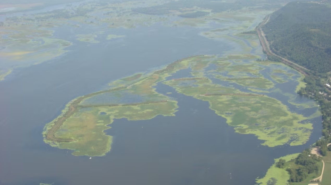
Established in 1937 with the construction of Lock and Dam 8, Pool 8 is a vital component of the Upper Mississippi River (UMR) system, designed to maintain the UMR navigation channel at a crucial depth of nine feet. Extending over 20 river miles and covering 15,000 hectares, Pool 8 stretches from Dresbach, Minnesota, to Genoa, Wisconsin. As a part of the UMR National Wildlife and Fish Refuge, Pool 8 serves as a critical habitat for many fish species and is a key stopover for migrating waterfowl.
By the 1980s, Pool 8’s islands near Stoddard, Wisconsin, experienced substantial erosion primarily due to rising water levels. This increase in water level not only exposed previously protected areas to the damaging effects of wind and waves but also shifted serene backwaters into turbulent riverine conditions. Consequently, the increased sediment deposition, and turbidity caused the loss of essential aquatic plant beds, particularly wild celery (Vallisneria americana), a primary forage food for many species of fish and waterfowl. To address the rapid decline of Pool 8’s habitat quality, the US Army Corps of Engineers (USACE) St. Paul District (MVP) led the Pool 8 Habitat Rehabilitation and Enhancement Project (HREP). This project beneficially used maintenance dredged sediments from the UMR navigation channel to restore the Pool 8 area, focusing on restoring a diverse mosaic of islands, floodplains, wet meadows, and backwater sloughs.
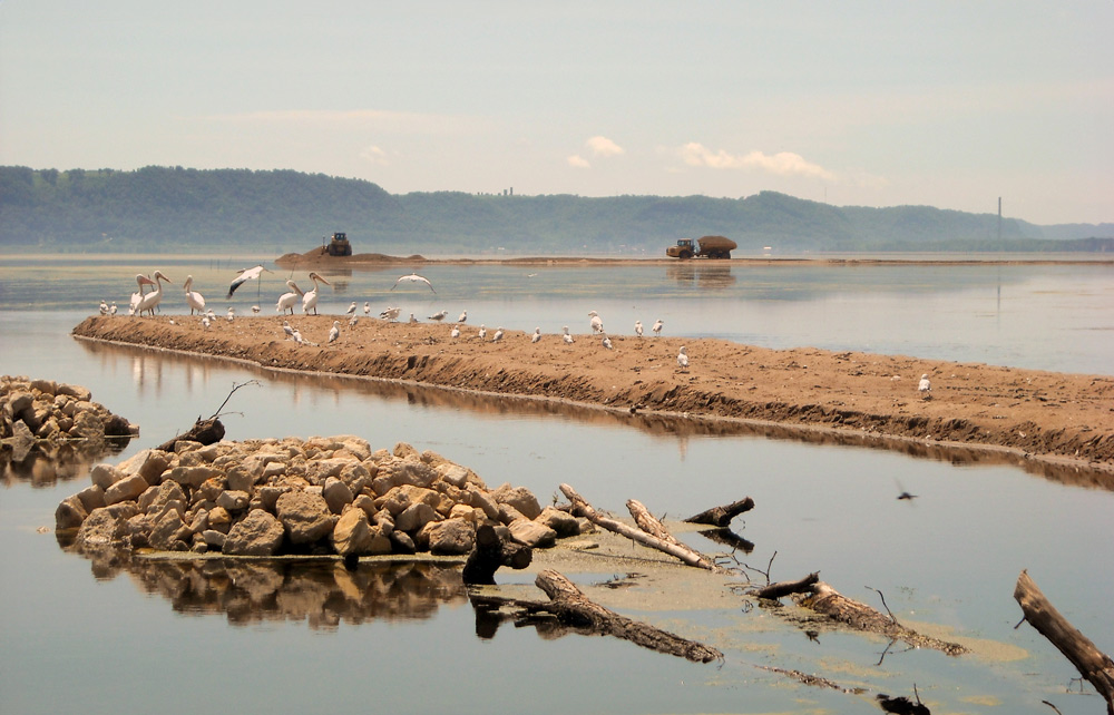
From 1990 to 2012, the Pool 8 HREP was executed in three phases, by MVP, in collaboration with the US Fish and Wildlife Service, US Geological Survey, Minnesota Department of Natural Resources, and Wisconsin Department of Natural Resources. The project, which had a design and construction cost of approximately $9 million and was entirely federally funded, strategically used both hydraulically and mechanically dredged sediment from the UMR. The sediment was used to construct the foundations of new islands and to stabilize existing island shorelines, resulting in over 30,000 linear feet of restored shoreline. The project team planted willow saplings and constructed rock groins to protect new land, adding sacrificial sand berms to further mitigate erosion. By completing work in phases, the project team was able to maximize the efficacy of placement methods, adaptively modifying work plans, as needed.
By 2015, the Pool 8 HREP was celebrated as a tremendous success, evidenced by the post-construction monitoring results. There were notable improvements in water quality, fish, and wildlife populations. Vegetation metrics showed the abundance of submergent, emergent, and rooted floating vegetation increased since 1998. Remarkably, wild celery increased from approximately 10% in 1998 to approximately 45% cover in 2015. Similarly, wild rice (Zizania aquatica), crucial for fish and waterfowl, grew from approximately 5% coverage to approximately 25% during the same period. Additionally, the project led to a resurgence of locally rare aquatic plant species.
The Pool 8 HREP not only rehabilitated a rapidly degrading ecosystem but also maintained the vital nine foot navigation channel of the UMR. The project’s strategic dredging and sediment placement restored the lower Pool 8 to its natural backwater condition, providing a sanctuary for culturally and recreationally important fish and waterfowl species. This initiative showcased how large-scale, beneficial use projects can achieve remarkable environmental restoration, serving as a blueprint for future restoration programs along the UMR.
Gallery:

Further readings:
- USACE St. Paul District. (1993). Operation and Maintenance Manual, Environmental Management Program (HREP): Pool 8 Island Construction Phase I, Vernon County, Wisconsin. December.
- USACE St. Paul District. (2000). Upper Mississippi River System Environmental Management Program, Operation and Maintenance Manual: Pool 8 Islands Phase II Habitat Rehabilitation and Enhancement Project. September.
- USACE St. Paul District. (2002). Upper Mississippi River System Environmental Management Program, Definite Project Report/Environmental Assessment (SP-24): Pool 8 Islands Phase III Habitat Rehabilitation and Enhancement Project. April.
- USACE St. Paul District. (2004). Pool 8 Island Construction - Phase I Project Completion Report. September.
- USACE St. Paul District. (2012). Upper Mississippi River System Environmental Management Program, Pool 8 Phase III, Upper Mississippi River, Vernon County, Wisconsin, Operation and Maintenance Manual.
- Wisconsin Department of Natural Resources. (2016). Upper Mississippi River Pool 8 Long Term Resource Monitoring - 2015 Status Report.
Website links:
- USACE Rock Island District. (2023). Pool 8 Islands, Phase I Habitat Rehabilitation and Enhancement Project.
- USACE Rock Island District. (2023). Pool 8 Islands, Phase II Habitat Rehabilitation and Enhancement Project.
- USACE Rock Island District. (2023). Pool 8 Islands, Phase III Habitat Rehabilitation and Enhancement Project.
Videos:
Pool 8 Islands Project. YouTube, Uploaded by MVP Public Affairs, 15 June 2010.