
A BRIEF SUMMARY OF A MULTI-DECADAL ASSESSMENT OF DREDGED SEDIMENT BENEFICIAL USE PROJECTS
- Title: A Brief Summary of a Multi-Decadal Assessment of Dredged Sediment Beneficial Use Projects
- State: Connecticut, Florida, Georgia, Michigan, Oregon, Texas
- Project type: USACE
- Greater Beneficial Use Area: Gulf of Mexico, Great Lakes, Columbia River, Connecticut River
- Focus Area approximate center coordinates: Multiple sites
- Nearest Federal Navigation Project: Houston Ship Channel, Gulf Intracoastal Waterway, Two-Mile Channel, Atlantic Intracoastal Waterway, Connecticut River, Lake Erie Ship Channel, and Columbia River
- Owner: USACE Districts - Detroit, Galveston, Mobile, New England, Portland, and Savannah
- Project Partners: Multiple partners
- Beneficial Use Categories: Wetland Habitats, Upland Habitats
- Dredge type: Hydraulic
- Status: Assessment Completed in 2019
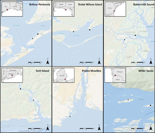
- Keywords: Bolivar Peninsula, Drake Wilson Island, Buttermilk Sound, Nott Island, Pointe Mouillee, Miller Sands, habitat
Description:
In the mid-1970s, various districts of the US Army Corps of Engineers (USACE) implemented beneficial use projects across different coastal areas as part of the Dredged Material Research Program. These projects were carried out in 1974 at Nott Island, CT, and Miller Sands, OR; in 1975 at Buttermilk Sound, GA; in 1976 at Bolivar Peninsula, TX and Drake Wilson Island, FL; and in 1979 at Pointe Mouillee, MI. Despite unique circumstances at each site, the objective of all these projects was to restore the local ecosystem by utilizing dredged sediment to create high-quality habitats, including dunes, marshes, and uplands. At each site, USACE either added new dredged sediment or contoured the existing dredged sediment to mimic natural conditions such as the grain size distribution of surface soil and variations in elevation. The use of “hard” engineering material such as dikes and rip rap was minimized at most project sites, and the sites were revegetated using natural recruitment and manual planting.
Post-construction monitoring of the beneficial use projects showed that these approaches were effective in improving habitat and ecological function. This success demonstrated the benefits of incorporating dredged sediment into ecosystem restoration programs designed to manage sediment from federal navigation projects. Thanks to these early projects, the beneficial use of dredged sediment is now commonly incorporated into modern-day navigation programs, and ongoing research seeks to further promote this approach. Recent studies have demonstrated how the ecological functions improved by beneficial use projects are linked to a full suite of ecosystem goods and services that are valuable to society (Berkowitz et al. 2022a, ), as well as how such functions are connected to engineering benefits (Berkowitz et al. 2021).
Despite the successes of engineered beneficial use sites, the decision-maker’s ability to account for project benefits over decadal timescales has been limited due to the unclear long-term ecological trajectory of such sites. This data gap was created by the absence of “mature” sites, as most beneficial use projects were completed relatively recently (< 30 years ago), compared to natural ecological succession, which can take up to hundreds or thousands of years. Furthermore, most beneficial use projects are monitored for only two to five years after completion, which further limits the opportunity to collect long-term information on these projects. To address these critical data gaps, Berkowitz et al. (2021; 2022a, b) assessed recent conditions for six USACE beneficial use projects completed in the 1970s and then compared those conditions to nearby natural areas. The research team used similar methods to analyze site changes over time relative to each respective reference area, assessing vegetation (stem density and species counts), bird use (fixed point species counts), and soil/sediment characteristics (physicochemical parameters, below-ground biomass). Berkowitz et al. (2021; 2022a, b) provides detailed information on the key results obtained.
Throughout the study period spanning from 1974 to 2019, most of the beneficial use sites demonstrated an increase in total land cover and vegetation abundance with a concurrent decrease in open water and barren land. The six projects combined to create new land at an average rate of 0.33 hectares per year, establishing over 70 hectares since their construction. The vegetation communities observed in beneficial use sites were more ecologically complex than those of the reference areas. For example, Bolivar Peninsula showed a notable increase in distinct plant communities from 6 to 10 between 1988 and 2019, while only one plant community was identified in the reference marsh at Pepper Grove in 2019. Effective remediation of bird habitat similarly demonstrated a higher average number of bird species in beneficial use areas compared to reference areas, most likely due to the different vegetative communities available in the former. Additionally, both beneficial use locations and reference areas appeared to respond comparably to fluctuations in environmental conditions. For example, increasing and decreasing trends in stem density at beneficial use sites mirrored those of reference sites, demonstrating the overall functionality and integrity of remediated areas. Soil organic matter increased over time at beneficial use sites, and in most cases approached similar values observed in reference locations. Soils created from dredged sediment also exhibited several other similarities to reference sites in pH, salinity, and bulk density. Although below-ground biomass at the beneficial use sites was significantly lower than reference conditions, it steadily trended upward over time in proportion to correlated increases in the other parameters. Overall, the assessment by Berkowitz et al. (2022) demonstrated that functional habitats can be effectively developed through beneficial use projects, yielding long-term, desirable ecological outcomes.
The study by Berkowitz et al. (2021; 2022a, b) is the first study of its kind to document the delivery of ecosystem functions by dredged sediment beneficial use projects across a multi-decadal period. It confirmed that projects incorporating natural processes in their design, similar to the earliest projects, generally maintained target habitats and ecological functions over decades. This new assessment also provides a framework for monitoring and evaluating the beneficial use of dredged sediment in current and future projects. One of the key takeaways is that although beneficial use areas become more like unaltered reference areas over time, they remain on distinct trajectories that do not always align directly with reference conditions. Therefore, it is important to consider the wider ecosystem goods and services they provide when defining project goals and measures of success. Taken together, the data provided by the earliest beneficial use projects, as assessed by Berkowitz et al. (2021; 2022a, b), promotes further beneficial use project design, construction, and management based on anticipated long-term ecological trajectories that can benefit navigation maintenance and society through improved ecosystems.
References:
- Berkowitz JF, Beane NR, Philley KD, Hurst NR, and Jung JF. (2021). An Assessment of Long-Term, Multipurpose Ecosystem Functions and Engineering Benefits Derived from Historical Dredged Sediment Beneficial Use Projects. ERDC/EL TR-21-4. USACE, Engineer Research and Development Center. July.
- Berkowitz JF, Beane NR, Hurst NR, Jung JF, and Philley KD. (2022a). A multi-decadal assessment of dredged sediment beneficial use projects part 1: Ecological outcomes. WEDA Journal of Dredging. 20(1):50–71.
- Berkowitz JF, Hurst NR, Beane NR, Philley KD, and Jung JF. (2022b). A multi-decadal assessment of dredged sediment beneficial use projects part 2: Ecosystem functions, goods, and services. WEDA Journal of Dredging. 20(1):72–89.
Further readings:
- Berkowitz JF, Philley KD, and Beane NR. (2021). Revisiting historic dredged material habitat improvement sites informs the future of beneficial use initiatives. Proceedings of the Western Dredging Association Dredging Summit & Expo ‘21, Virtual Conference, USA, June 15 - 18, 2021.
- Allen HH, Clairain EJ, Diaz RJ, Ford AW, Hunt J, and Wells BR. (1978). Habitat Development Field Investigations: Bolivar Peninsula, Marsh, and Upland Habitat Development Site, Galveston Bay, Texas. Technical Report D-78-15. Vicksburg, MS: USACE, Dredged Material Research Program. August.
- Kruczynski WL and Huffman RT. (1978). Habitat Development Field Investigations, Apalachicola Bay Marsh Development Site, Apalachicola Bay, Florida. Technical Report D-78-32. Vicksburg, MS: USACE, Waterways Experiment Station. August.