
MOUTH OF COLUMBIA RIVER, OREGON-WASHINGTON
- Title: Nearshore dredge material placement sites to supply littoral cell near mouth of Columbia River
- State: Oregon and Washington
- Project type: USACE
- Greater Beneficial Use Area: Pacific Ocean, Pacific Northwest Coast
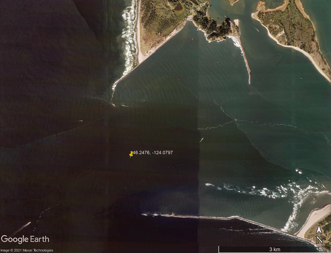
- Focus Area approximate center coordinates: 46.2476, -124.0797 (Mouth of Columbia River)
- Nearest Federal Navigation Project: Mouth of Columbia River
- Owner: USACE Portland District
- Beneficial Use Categories: Beach/Shoreline Nourishment
- Dredge type: Hydraulic
- Status: Ongoing
- Keywords: jetty, sand, shoreline recession, strategic placement
Description:
The mouth of Columbia River (MCR) on the Oregon-Washington border is one of the most energetic coastal inlets in the world. Annually millions of cubic yards of sediment are transported by the combined action of tides, wind, waves and their resulting currents. At the MCR is a six mile long federal navigation channel created and maintained by the US Army Corps of Engineers Portland District (USACE NWP). The navigation channel is critically important for the regional and national economy. To help protect the coastal inlet and navigation channel from powerful natural forces jetties were constructed by NWP between 1885 and 1939. Although the jetties help to protect the coastal inlet, the MCR entrance channel still requires annual dredging of sediment composed predominately of uncontaminated fine sands in the range of 3 to 5 million cubic yards per year. Over the years, shoreline recession has occurred near the MCR and can be attributed, in part, to sediment retention by Columbia River dams, navigation channel dredged sediment disposal practices, and jetty construction.
Historically, a large portion of the sediment dredged from the MCR was placed into ocean dredged material disposal sites located offshore of the MCR. But, once shoreline recession near MCR was recognized the NWP through studies generated critical information about sediment transport in the MCR which was used to help improve navigation channel dredged sediment disposal practices. To maintain the critically important navigation channel as well as address shoreline recession, a large portion of sediment dredged from the MCR federal navigation channel is now being placed by hopper dredges into strategically selected dredge sediment placement sites located in the littoral zone near the north and south jetties of the MCR. The benefits of this strategic placement is an improved littoral sediment budget, a portion of which will contribute to beach nourishment, and stabilization of the north jetty.
The NWP continues to monitor sediment transport in the MCR and study the effects of nearshore and offshore placement on aquatic resources (e.g., demersal fish and crab communities) the results of which are used to adaptively manage sediment placement. The size and location of the dredge sediment placement sites located in the littoral zone have been modified several times to achieve greater return of sediment to the eroding shorelines. The NWP works closely with the US Environmental Protection Agency, the states of Oregon and Washington, and Lower Columbia Solutions Group to achieve the beneficial use of dredged sediment.
Website links:
- USACE Portland District. “Building Strong® at the Mouth of the Columbia River.”
- USACE Portland District. “Mouth of Columbia River Jetty System Major Rehabilitation Project.”
- Lower Columbia Solutions Group. “The MCR Regional Sediment Management Plan.”
Further readings:
- Gailani J, Brutsche KE, Godsey E, Wang P, Hartman MA. (2019). Strategic Placement for Beneficial Use of Dredged Material. ERDC/CHL SR-19-3. Engineer Research and Development Center Vicksburg MS.
- Fields S, Henkel S, Roegner GC. (2019). Video sleds effectively survey epibenthic communities at dredged material disposal sites. Environmental Monitoring and Assessment 191: 404.
- Lower Columbia Solutions Group. 2011. Mouth of the Columbia River regional sediment management plan.
- Moritz H, Puckette T, Marsh J, Boudreau R, Siipola M, Ott M. (2011). Utilizing sediment tracer studies to evaluate transport pathways at the Mouth of the Columbia River, USA. Proceedings of the Coastal Sediments ’11 Specialty Conference, Miami, FL, USA, May 2-6, 2011.
- Norton JK, Moritz HK, Ott ME, McMillan JM, Roegner GC. (2018). Advanced monitoring of dredged material placement sites at the mouth of the Columbia River. Proceedings of the Western Dredging Association Dredging Summit & Expo ’18, Norfolk, VA, USA, June 25-28, 2018.
- Roegner GC, Fields SA. 2015. Mouth of the Columbia River Beneficial Sediment Deposition Project: Benthic Impact Study 2014. Report of the National Marine Fisheries Service to the US Army Corps of Engineers. Portland, Oregon.
- Stevens AW, Elias E, Pearson S, Kaminsky GM, Ruggiero PR, Weiner HM, Gelfenbaum GR. (2020). Observations of coastal change and numerical modeling of sediment-transport pathways at the mouth of the Columbia River and its adjacent littoral cell: U.S. Geological Survey Open-File Report 2020–1045, 82 p.
- USACE/U.S. Environmental Protection Agency (USEPA). 2016. 2017 Annual Use Plan: Management of Open Water Dredged Material Placement/Disposal Sites, Mouth of the Columbia River, Oregon and Washington. Portland OR: Report by the US Army Corps of Engineers, Portland District, and U.S. Environmental Protection Agency Region 10.