MOBILE BAY, ALABAMA

- Title: Placement of dredged sediment into Brookley Hole, an estuarine dredged borrow pit in Mobile Bay, Alabama
- State: Alabama
- Project type: USACE
- Greater Beneficial Use Area: Mobile Bay, Gulf of Mexico
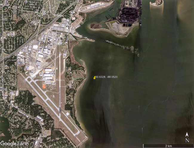
- Focus area approximate center coordinates: 30.6328, -88.0520 (Brookley Hole)
- Nearest Federal Navigation Project: Mobile Harbor
- Owner: USACE Mobile District
- Beneficial Use Categories: Aquatic Habitats
- Dredge type: Hydraulic
- Status: 2012
- Keywords: Reclaim, dredged burrow pit, ecological productivity, Mobile Bay Interagency Working Group
Description:
The Mobile Harbor Federal Navigation Project is maintained by the USACE Mobile District (SAM). Mobile Bay, Alabama, is the terminal repository of sediments transported downstream from the Mobile-Tensaw River system, which is the nation’s fourth largest river system relative to flow volume and sixth largest in terms of total drainage area. Historically, the majority of sediments composed predominately of uncontaminated fine sediments from the Mobile Bay navigation channel were excavated by cutterhead dredges and side-casted into open water disposal sites parallel to the channel resulting in mounds of dredged sediments. Beginning in 1970s, this practice stopped and instead hopper dredges were used to excavate sediment which was then transported offshore up to 40 miles to ocean dredged material disposal sites in the Gulf of Mexico. During this time, the SAM recognized Mobile Bay was losing habitat, in part, to a sediment deficit in the bay. The sediment deficit was approximately 1.6 million cubic yards of sediment per year which is less than the volume of sediment dredged from the navigation channel each year (approximately 4 million cubic yards).
SAM recognized that removal of dredged sediment from Mobile Bay to the offshore placement sites in the Gulf of Mexico may not be the most environmentally appropriate method of disposing of dredged sediment and may have long-term negative effects in Mobile Bay because the sediment is no longer available to the bay system. Therefore, beneficial use of dredge sediment in the Mobile Bay was seen as an environmentally accepted alternative to disposal in the Gulf of Mexico. The intention of the beneficial uses was to modify the present navigation channel dredged sediment disposal practices by developing a strategy for Mobile Bay that meets the operation and maintenance needs for the Mobile Harbor Navigation Project as well as environmental standards. From these needs the Mobile Bay Interagency Working Group (IWG) was established to identify and implement environmentally acceptable disposal options.
Brookley Hole was identified as a beneficial use site. Brookley Hole is a dredged burrow pit from which sediment was removed for the construction of Brookley Air Field runway adjacent to the bay. SAM conducted baseline surveys of the hole which revealed degraded ecological productivity (e.g., benthic community) as a result of hypoxic conditions in the pit. In 2012, the hole was partially filled with approximately 1.2 million cubic yards of sediment dredged from the upper Mobile Bay navigation channel. After partial filling, monitoring continued and revealed that hypoxia conditions no longer occurred and ecologically productivity quickly returned to the site. Although much improved, productivity was still lower when compared to surrounding bay waters, but this is partially contributed to remaining deeper water depths in the hole relatively to the surrounding bay waters. Brookley Hole still remains a suitable candidate for continued partial or complete filling with dredged sediment from the Mobile Bay navigation channel.
The SAM, as part of the IWG worked closely with partners to achieve this beneficial use of dredged sediment. The SAM performed several pre- and post-sediment placement monitor efforts at Brookley hole to document the changes at the site in order to further refine the practice of filling aquatic burrow pits.
Website links:
Further readings:
- Kress MM, Touzinsky KF, Vuxton EA, Greenfeld B, Lillycrop LS, Rosati JD. (2016). Alignment of USACE civil works missions to restore habitat and increase environmental resiliency. Coastal Management 44:193-208.
- Reine KJ, Clarke DG, Dickerson C. (2013). Pre-restoration assessment of fishery resource utilization of an estuarine borrow pit in Mobile Bay, Alabama. Technical Note ERDC TN-DOER-E37. Vicksburg, MS: US Army Engineer Research and Development Center.
- Reine KJ, Clarke DG, Ray GL. (2014). Fishery resource utilization of an estuarine borrow pit in Mobile Bay, Alabama. Technical Report ERDC-EL-TR-14-10. Vicksburg, MS: US Army Engineer Research and Development Center.
- Reine K, Clarke D, Ray G, Dickerson C. (2013). Fishery resource utilization of a restored estuarine borrow pit: A beneficial use of dredged material case study. Marine pollution bulletin 73:115-128.
- Parson LE, Lovelace ND, Godsey ES, Reine KJ, Gailani JZ. (2015). Regional sediment management (RSM) strategy for Mobile Bay, Alabama. ERDC-CHL-CHETN-XIV-41. Engineer Research and Development Center Vicksburg MS.
- US Army Corps of Engineers (USACE). (2012). Brookley Hole demonstration: Beneficial use of dredge material from Mobile Harbor federal navigation channel Mobile county, Alabama. Draft Environmental Assessment and 404(b)(1) Evaluation Report – Brookley Hole, Alabama. Report by USACE Mobile District Planning and Environmental Division, Environment and Resources Branch, Coastal Environment Team.

