
JEKYLL CREEK, GEORGIA
- Title: Jekyll Creek Beneficial Use of Dredged Material Pilot Project
- State: Georgia
- Project type: USACE
- Greater Beneficial Use Area: Atlantic Ocean
- Focus Area(s) approximate center coordinates: 31.0901, -81.4321 (thin layer placement site); 31.1313, -81.3980 (Deep Hole)
- Nearest Federal Navigation Project: Atlantic Intracoastal Waterway, GA
- Owner: Savannah District, Jacksonville District
- Beneficial Use Categories: Wetland Habitats
- Dredge type: Hydraulic
- Status: completed in 2019
- Keywords: St. Simons Sound, Pluff Mud, Deep Hole, Thin Layer Placement
Description:
Jekyll Creek, located in Georgia, makes up a portion of the 3,000 mile Intracoastal Waterway (ICW) which is an inland waterway extending the Atlantic and Gulf of Mexico coasts. The creek is the shallowest point along a 160 mile stretch of the ICW running through Georgia and had not been dredged since 1998. To ensure safe navigation for commercial and recreational vessels, dredging of the creek was needed. Historically, the dredged sediment would be transported to a nearby ocean dredged material disposal site or to an upland disposal facility where the sediment would no longer be available to the river system and marsh areas. Coastal marsh resilience faces multiple threats which often center on the role of sea level rise as affected by climate change. River discharge and channel morphology also play a key role in supplying much needed sediment to coastal marsh areas which are increasingly sediment starved due to anthropogenic activities. The USACE is responsible for maintaining the nation’s waterways for safe navigation and acknowledges keeping sediment available in the system is an important consideration.
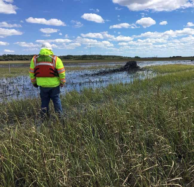
Beginning in 2016, the USACE Savannah District partnered with the Jacksonville District who worked with the USACE Regional Sediment Management Center of Expertise, as well as other federal, state and nonprofit agencies including: the Georgia Department of Nature Resources Coastal Resources Division, the Jekyll Island Authority, The Nature Conservancy, National Oceanographic and Atmospheric Administration, U.S. Fish and Wildlife Service, and the U.S. Environmental Protection Agency to develop several pilot projects with the aim to beneficially use the dredged sediments in environmentally and economically efficient ways. From these collaborations, a 2-hectare thin-layer placement (TLP) project on Jekyll Island was created to understand the potential benefits of this placement strategy in the region. TLP broadly encompasses the purposeful placement of sediment or dredged sediment in a manner that produces a specific layer thickness or ground surface elevation necessary to achieve the overall project objectives which in this case was to increase coastal marsh resiliency. This TLP project posed significant engineering challenges and required strategic and innovative solutions due to the type of dredged sediment and the large tidal range at the placement location. The dredged sediment from the Jekyll Creek area is often called Pluff Mud because it is composed mostly of fine grained sediments with low sand content which makes it difficult to work with. Coconut coir logs were placed around the TLP project site in order to contain sediment and limit turbidity outside the project area during tidal changes.
Additionally, a naturally deepened area located north of Jekyll Creek in the St. Simons Sound and about 250 m south of the St. Simons Pier known as the “Deep Hole” was identified as an area to safely place sediments without obstructing navigation, but also kept the sediments in the system where tides could naturally disperse the sediments and scientist could study sediment transport pathways to learn more about the fate of sediments in the area. About 97% of the 220,000 cubic yards of dredged sediment was placed in the Deep Hole while the remainder was used for TLP.
Scientists from the Georgia Southern University, the University of South Carolina, and US Army Engineer Research and Development Center have been monitoring the TLP site for the past two years to learn more about changes to the coastal marsh area. The Jekyll Island Authority and The Nature Conservancy teamed up to purchase an elevated camera system which provides imagery of the TLP site on a daily basis. Scientists with LG2 Environmental Solutions, Jacksonville, FL, are monitoring sediments placed in the Deep Hole through sediment tracer studies which will provide better information concerning sediment transport pathways and fate of placed sediments in the Deep Hole and surrounding coastal area.
Presentations:
- McCoy C. 2018. Jekyll Creek: Beneficial Use Pilots. Presentation at the Western Dredging Association, Eastern Chapter Meeting, Savannah, GA, USA, October 16-18, 2018.
Featured in Engineering With Nature: An Atlas Volume 2:
- Bridges TS, Bourne EM, Suedel BC, Moynihan EB, King JK. 2021. Engineering With Nature: An Atlas, Volume 2. ERDC SR-21-2. Vicksburg, MS: US Army Engineer Research and Development Center.
Websites:
- Visit the USACE Engineering With Nature website at www.engineeringwithnature.org.
- Visit the USACE Thin Layer Placement website at https://tlp.el.erdc.dren.mil/.
News releases:
- Larimer W. 2019. Beneficial Use Pilot Project Underway for Jekyll Creek. The Waterways Journal Weekly. 24 April 2019.
- Georgia Department of Natural Resources Coastal Resources Division. (7 March 2019). Jekyll Creek dredging project to begin staging March 11 [News Release].
Further Readings:
- Berkowitz JF, Piercy C, Welp T, VanZomeren CM. 2019. Thin Layer Placement: Technical definition for US Army Corps of Engineers applications. ERDC/EL TN-19-1. US Army Engineer Research and Development Center, Vicksburg, MS.
Images:
- Jekyll Thin Layer Placement. Camera monitoring system provided by Jekyll Island Authority and The Nature Conservancy. Ongoing.
Videos:
CRD Surveys Jekyll Creek Dredge Project. YouTube, uploaded by Georgia DNR Coastal Resources Division, 29 May 2019.
Jekyll Creek Dredging Information. YouTube, uploaded by Georgia DNR Coastal Resources Division, 8 March 2019.
Jekyll Creek Thin Layer Placement Pilot Project. YouTube, uploaded by SavannahCorps, 12 June 2019.