HORSESHOE BEND ISLAND, LOUISIANA

- Title: Horseshoe Bend Island
- State: Louisiana
- Project type: USACE
- Greater Beneficial Use Area: Atchafalaya River, Morgan City, Louisiana
- Focus Area(s) approximate center coordinates: 29.5294, -91.2768
- Nearest Federal Navigation Project: Atchafalaya River and Bayous Chene, Boeuf, and Black
- Owner: USACE New Orleans District
- Beneficial Use Categories: Island Habitats
- Dredge type: Hydraulic
- Status: completed in 2014
- Keywords: island creation, dredged sediment, ecosystem enhancement, restoration, carbon sequestration, Horseshoe Bend Island
Description:
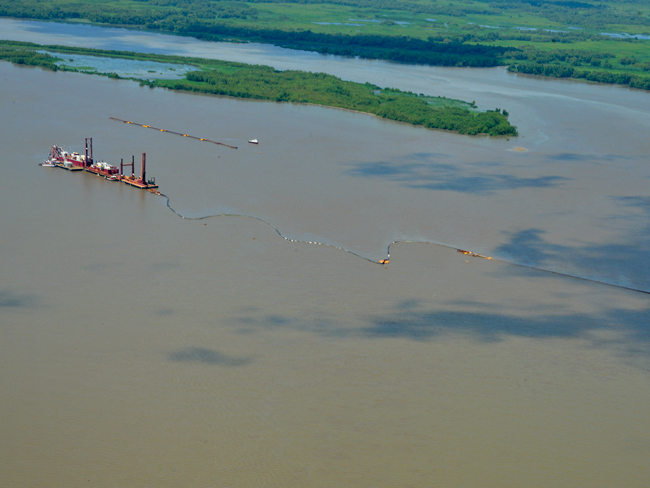
The Atchafalaya River and Bayous Chene, Boeuf, and Black Federal navigation channel includes Horseshoe Bend, a meandering reach in the lower Atchafalaya River about 20 miles south of Morgan City, Louisiana. Beginning in 1990, annual maintenance dredging events of this reach were required in order to maintain safe navigation and access to port facilities further upstream. Initially, dredged sediment was placed at multiple wetland development sites adjacent to the navigation channel, but capacity of these placement sites was soon exhausted. Rather than expensive conversion of wetland development sites to upland disposal areas or pumping dredge sediment through a pipeline to distant open water disposal sites, the USACE New Orleans District (MVN) chose to investigate the effects of strategic placement of dredged sediments in unconfined mid-river areas upstream of Horseshoe Bend on downriver shoaling. This strategy was chosen to help reduce dredging costs and to investigate ways in which downriver shoaling could be manipulated to benefit navigation, dredging, and the environment.
In 2002, USACE began to place dredged sediment upstream of Horseshoe Bend at a naturally forming sandbar. The river current and strategic placement of dredged sediment provided a source of sediments that contributed to downstream shoaling and eventually the creation of a 35 hectare (87-acre) mid-river island, later named Horseshoe Bend Island. This strategy not only helped to reduce dredging costs and increase navigation efficiency, but it also created an island habitat for wildlife and increased recreational opportunities. Multiple sets of aerial photographs of the area taken from before, during, and after project inception in 2002 clearly document the island's growth.
As of 2018, Horseshoe Bend Island boasted around six hectares of emergent habitat, around seven hectares of aquatic bed habitat, 81 plant species, and 23 animal species (nine of which were wading birds). In an ecological assessment performed by USACE, it was determined the island contained the highest plant species richness and number of wading bird nesting colonies compared with: nearby Island E, an island created by pumping dredged sediment directly onto a designated disposal area rather than through river currents; and Middle Island, a mature, naturally formed wetland island. Bird species observed at Horseshoe Bend Island include tricolored heron (Egretta tricolor), snowy egret (E. thula), and glossy ibis (Plegadis falcinellus). Signs of human activity have been observed on the island, with the presence of shotgun shells indicating the island has been used for hunting.
The creation of Horseshoe Bend Island through strategic placement of dredged sediments coincided with the development of a more efficient river channel east of Horseshoe Bend Island. The new river channel formed because of the decreased cross-sectional river area, which increased river flow velocity and sediment transport through this new channel. The new channel was designated by the US Coast Guard in 2015 as the new federal navigation channel because of its shorter length (1.13 kilometers shorter), fewer turns, and lower shoaling rates, which thereby substantially reduced dredging frequency and volumes from ~1.1 million cubic yards per annual event to ~750,000 cubic yards once every three years. Studies conducted by USACE to investigate the Horseshoe Bend Island formation and channel relocation showed that using dredged sediments to create Horseshoe Bend Island supported wetland formation and expansion while providing habitat, hydrologic, and biogeochemical functions. It is estimated that Horseshoe Bend Island sequesters an average of 5,220 kilograms of carbon annually. The nutrients sequestered in the island's sediments also reduce the load delivered to the northern Gulf of Mexico, where hypoxia is an ongoing concern. To this day, Horseshoe Bend Island continues to provide ongoing economic and environmental benefits and is an innovative example of beneficially using dredged sediment in a riverine project.
Presentations:
- Corbino J. 2013. Horseshoe Bend: An Engineering with Nature Case Study [Presentation].
- Kim S-C, Suedel B. 2015. Hydrodynamic and Sediment Transport Modeling for Horseshoe Bend Island Creation in the Lower Atchafalaya River, Louisiana [Presentation]. Western Dredging Association 2015 Dredging Summit and Expo, Houston, Texas.
Websites:
- Central Dredging Association. Creating Islands. Beneficial Use of Sediments: Case Studies.
Press releases:
- USACE. 2020. Using Natural Forces, Sediment to Restore Coastal Marsh Habitat. Engineering With Nature Podcast, Season 1: Episode 2.
Further Readings:
- Berkowitz JF, Beane NR, Evans Burton DE, Corbino JM. 2014. Use of Strategic Placement of Dredged Sediments to Support Horseshoe Island in the Atchafalaya River, Louisiana: A Preliminary Ecological Survey. ERDC TN-EWN-14-4. US Army Engineer Research and Development Center, Vicksburg, MS.
- Berkowitz JF, Hurst NR. 2022. New initiatives improve wetland restoration outcomes: Engineering with nature and the use of natural and nature-based features. Wetland Science and Practice. 40(2):28–32.
- Foran CM, Burks-Copes KA, Berkowitz J, Corbino J, Suedel BC. 2018. Quantifying wildlife and navigation benefits of a dredging beneficial-use project in the lower Atchafalaya River: A demonstration of Engineering with Nature®. Integrated Environmental Assessment and Management. 14(6):759–768.
- Suedel BC, Berkowitz JF, Foran C, Corbino JM. 2017. Project Name: Horseshoe Bend Island. US Army Engineer Research and Development Center, Vicksburg, MS.
- Suedel B, Berkowitz J, Kim S-C, Beane N, Summers E, Evans D, Corbino J. 2015. Creating Horseshoe Bend Island, Atchafalaya River, Louisiana. Terra et Aqua. 140:26–31.
- USACE. 2021. Horseshoe Bend Island. Built Projects. Engineering With Nature. May 6.
- Whitfield PE, Suedel BC, Egan KA, Corbino JM, Davis JL, Carson DC, Tritinger AS, Szimanski DM, Balthis WL, Gailani JZ, King JK. 2022. Engineering With Nature® Principles in Action: Islands. ERDC TR-22-9. US Army Engineer Research and Development Center, Vicksburg, MS.

