
NEARSHORE BERM PLACEMENT FOR BEACH
NOURISHMENT AT FORT MYERS BEACH
- Title: Nearshore Berm Placement for Beach Nourishment at Fort Myers Beach
- State: Florida
- Project type: USACE
- Greater Beneficial Use Area: Fort Myers Beach, Matanzas Pass Navigation Channel, Florida Coast, Gulf of Mexico
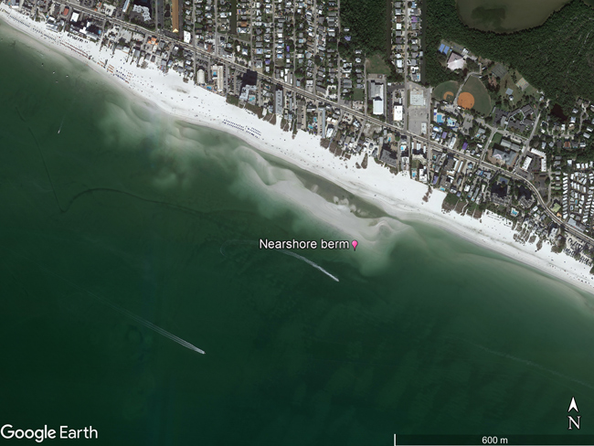
- Focus Area(s) approximate center coordinates: 26.4453, -81.9437 (nearshore berm)
- Nearest Federal Navigation Project: Fort Myers Beach FL Navigation Project
- Owner: USACE Jacksonville District
- Beneficial Use Categories: Beach/Shoreline Nourishment
- Dredge type: Hydraulic
- Status: Complete (May 2009)
- Keywords: Beach Nourishment, Fort Myers Beach, Matanzas Pass Federal Navigation Channel, Berm
Description:
The Matanzas Pass Federal Navigation Channel is maintained by the USACE Jacksonville District (SAJ). The pass is located at the northern tip of Estero Island on the Florida Gulf Coast and is primarily used by recreational and fishing vessels and serves as an access point for the US Coast Guard. The SAJ previously dredged the pass in 1986, 1996, and 2001. The pass required dredging again in 2009 with plans to beneficially use the dredged sediment as beach nourishment on nearby Fort Myers Beach. However, initial sampling of the shoaled sediments found that they contained fine grained particles (e.g., silts) which at 16% exceeded the State of Florida regulatory compatibility requirement of 10% fines. Therefore, the sediments could not be placed onto the Fort Myers Beach without first developing a method to remove the fine grained sediments.
In order to achieve sediment compatibility for beach nourishment, the sediments were placed nearshore of Fort Myers Beach in the shape of an elongated berm. This nearshore berm was approximately 3 ft high by 400 ft wide by 6,000 ft long, and 600 ft offshore. Here, tides, wind, waves and their resulting currents winnowed the berm sediments which moved the majority of fine grained sediments seaward while the more desirable sediments (i.e., sand) migrated shoreward eventually nourishing the beach. A total of 230,000 cubic yards were placed to construct the berm. Placement was in shallow water far enough away from the channel to prevent shoaling of the placed sediment back in the channel, but still allowed the desirable sediments to migrate onshore and nourish the beach. During construction, gaps perpendicular to the shoreline were made to allow for water circulation and to prevent ponding or water stagnation.
Changes in the nearshore berm and beach profile were monitored by SAJ and the University of South Florida (USF). Monitoring in the form of profile surveys occurred twice a year between placement in May 2009 and May 2013. The monitoring compared control areas northeast and southwest of the nearshore berm to the placement area. The control areas were not anticipated to be impacted by the dredged sediment placement. Results of the profile monitoring found that the berm migrated onshore during the 4-year monitoring period. As an added benefit, the berm also protected the beach from erosion by dissipating wave energy from two tropical storms that passed through during the monitoring period. The profile survey also showed that additional perpendicular gaps within the berm formed and allowed for water to circulate and for recreational vessels to access the beach.
Surface sediment samples were collected in 2010 and 2011. Sediment sampling showed that the fines moved offshore and the beach compatible sediment moved onshore and the overall grain size of the beach did not change. The dry beach gained 23,000 cy in volume and approximately 59 ft in width over the 4-year monitoring period. Monitoring also showed that the berm reached equilibrium with the system during the 4-year period. Since sediments migrated from the initial placement site via natural processes the area can be used again in the future as a sustainable means for beneficial sediment use. The monitoring provided by SAJ and USF allowed for a better understanding of the system and can be used to help plan future beneficial use projects with sediments that initially do not meet beach compatibility standards.
Further Readings:
- Brutsché KE, Pollock CE. 2017. Strategic placement of mixed sediment in the form of a nearshore berm along Fort Myers Beach, Florida. EWN Technical Notes Collection. ERDC TN-EWN-17-1. US Army Engineer Research and Development Center, Vicksburg, MS.
- Brutsché KE, Wang P. 2012. First year morphological evolution of an artificial berm at Fort Myers Beach, Florida. ERDC/CHL CHETN-II-54. US Army Engineer Research and Development Center, Vicksburg, MS.
- Brutsché KE, Wang P, Beck TM, Rosati JD, Legault KR. 2014. “Morphological evolution of a submerged artificial nearshore berm along a low-wave microtidal coast, Fort Myers Beach, west-central Florida, USA.” Coastal Engineering 91: 29–44.
- Gailani JZ, Brutsché KE, Godsey ES, Wang P, Hartman MA. 2019. Strategic Placement for Beneficial Use of Dredged Material. ERDC/CHL SR-19-3. US Army Engineer Research and Development Center, Vicksburg, MS.
- Wang P, Brutsché KE, Lagrone JW, Beck TM, Rosati JD, Lillycrop LS. 2013. Performance monitoring of a nearshore berm at Fort Myers Beach, Florida: Final report. ERDC/CHL TR-13-11. US Army Engineer Research and Development Center, Vicksburg, MS.