
CRAB BANK Seabird Sanctuary Restoration
- Title: Crab Bank Seabird Sanctuary Restoration
- State: South Carolina
- Project type: USACE
- Greater Beneficial Use Area: Charleston Harbor, Atlantic Ocean
- Focus Area(s) approximate center coordinates: 32.7789, -79.8846 (Charleston Harbor)
- Nearest Federal Navigation Project: Charleston Harbor Post 45 Project
- Owner: USACE Charleston District
- Beneficial Use Categories: Island Habitats
- Dredge type: Hydraulic
- Status: completed in 2021
- Keywords: island, dredged sediment, bird habitat, restoration, Charleston Harbor, island renourishment
Description:
The Charleston Harbor Federal Navigation Channel is maintained by the USACE Charleston District (SAC). The harbor is located in a natural tidal estuary formed by the confluence of the Cooper, Ashley, and Wando rivers in Charleston, South Carolina and is used for cargo transportation, recreation, and marine vessel activity. Charleston Harbor has been dredged annually for more than 140 years, removing 2 3 million cubic yards of shoaled sediment (i.e., maintenance dredging) from the harbor each year. In 2016, a capital dredging project, (Charleston Harbor Post 45 Deeping Project) designed by the Charleston District, deepened and widened the federal navigation channel to handle larger shipping vessels. The deepening of the federal navigation channel resulted in an estimated 50% increase of dredged sediment.
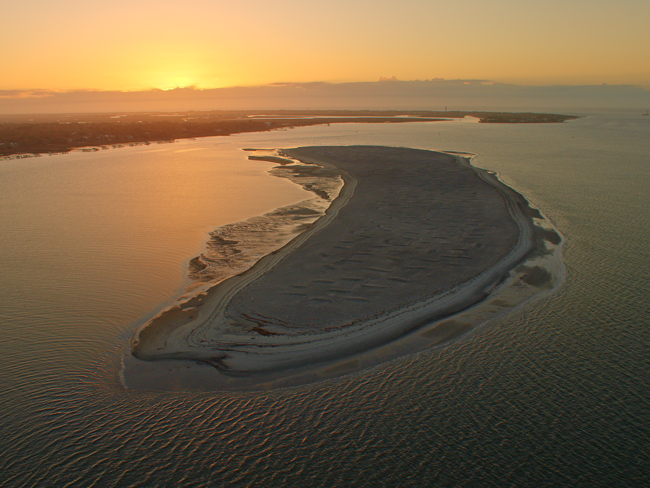
Historically, dredged sediment was transported to and disposed of in the ocean dredged material disposal site (a.k.a Charleston ODMDS) located offshore and adjacent to the entrance channel. While a portion of this sediment was transported to the ODMDS for disposal, the USACE also conducted an assessments to identify beneficial uses of the dredged sediment (see 33 CFR Part 335; ER 1105-2-100; ER 1130-2-520; and Policy Guidance Letter No. 56. ER 1105-2-100 on page E 69). Through this assessment, Crab Bank Seabird Sanctuary was identified as an appropriate site for placement of dredged sediment. Crab Bank Seabird Sanctuary is a 32 acre island located in Charleston Harbor near the mouth of Shem Creek in Mount Pleasant, South Carolina. In addition to providing rest and nourishment for hundreds of migrating shorebirds, Crab Bank also provides nesting habitat for many coastal birds, hosting an estimated 4,000 to 5,000 bird nests in a breeding season. Unfortunately following Hurricane Irma in 2017, most of the high ground used for nesting was washed away.
To help restore Crab Bank island, the SAC partnered with the South Carolina Department of Natural Resources (SCDNR) to share the cost of the beneficial use project which allowed for the placement of dredged sediment on the island. The restoration began in September 2021 and was completed in November 2021 during which time approximately 660,000 cubic yards of dredged sediment was placed on the island. The restoration of Crab Bank restored 35 acres of nesting habitat for coastal bird species, ranging between 5 and 8 feet above the high tide waterline. Colonies of nesting birds, such as brown pelicans, terns, plovers, and egrets are supported by Crab Bank's isolated beach habitat and lack of mammalian predators. No plantings have been completed as part of the original project; however, natural vegetation is expected to grow and colonize the island long-term. Crab Bank has been designated as an “Important Bird Area” in South Carolina by the National Audubon Society.
The SAC anticipates the placement of dredged sediment could support bird nesting on the island for up to 50-years. However, SAC and SCNDR recognize that in such a dynamic environment, the footprint may change with time, especially in the event of another hurricane. Since restoration was completed, SCDNR staff has conducted seasonal monitoring of Crab Bank through high-resolution aerial imagery and elevation measurements. The ongoing monitoring will allow SCDNR to adaptively manage and maintain the habitat created for nesting birds through future stabilization measures and with help from SAC, a plan for future placement of dredged sediment, as needed.
Websites:
- USACE. Charleston District Navigation.
- SCDNR. Seabird Sanctuaries – Crab Bank.
- Audubon. Important Bird Areas: Crab Bank.
- Audubon South Carolina. Crab Bank Seabird Sanctuary.
- USACE. Charleston Harbor Post 45 Overview. Charleston District.
News releases:
- Burnell D. 2021. Crab Bank Restoration Begins; Project Stresses Public Safety. USACE, Charleston District. September 23.
- Burnell D. 2022. Adding to the Galápagos of South Carolina: Return of Shorebirds to Crab Bank Worthy of Celebration. USACE, Charleston District. April 22.
- Hrvacevic Z. 2021. Crab Bank Restoration Project Complete. Dredging Today. December 6.
- Jefferies G. 2022. Crab Bank Seabird Sanctuary: A Landmark Legacy. USACE, Charleston District. January 16.
- SCDNR. 2022. Successful Shorebird Nesting Season on a Newly Restored Crab Bank. SCDNR News. October 11.
Further Readings:
- Rhodes RJ, Whitehead JC. 2002. Estimating the Economic Value and Economic Contribution of the Crab Bank Seabird Sanctuary.
- USACE. 2018. Charleston Harbor Section 204 Beneficial Use of Dredged Material, Charleston Harbor, South Carolina. Detailed Project Report.
- USACE. 2017. Final Supplemental Environmental Assessment Beneficial Uses for Charleston Harbor Deepening Project (Post 45). Charleston District.
- Water Environment Consultants. 2021. Storm Wave Impact Analysis. Crab Bank Seabird Sanctuary Project, Charleston, South Carolina. Prepared for Audubon South Carolina.
Videos and Live Webcam:
- Coastal Conservancy League. The Shutes Folly Pelicam.
Coastal Expeditions. Crab Bank Renourishment Day 1.
SCDNR. Crab Bank Seabird Sanctuary Nesting Season 2022 Highlights.
USACE. Restoring Crab Bank.